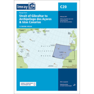
Description
This overview chart covers the sailing area from the Strait of Gibraltar westward in the North Atlantic to the Azores and the Canary Islands. The map is designed as a passage map and provides an overview of sea crossings between Southern Europe, North Africa and the archipelagos in the Eastern Atlantic.
The chart is particularly suitable for long-distance sailing and ocean crossing planning, focusing on large-scale route selection, distances and geographical overview. It is typically used in combination with more detailed coastal and harbor charts for departure and arrival areas.
Imray is a recognized British chart manufacturer with extensive experience in nautical cartography for leisure and long-distance sailing. Passage charts from Imray are designed to provide a good overview and support for strategic route planning over open sea areas.