Description
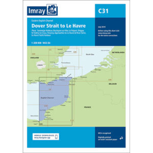
This boating map covers the eastern part of the English Channel from the Strait of Dover to Le Havre. The map includes detailed plans and approaches to key ports and coastal areas such as Dover, Boulogne-sur-Mer, Le Tréport, Dieppe, St-Valery-en-Caux, Fécamp, as well as the approaches to Le Havre and the Seine.
The chart is well suited for leisure boats and sailboats traveling in one of Europe’s busiest waters, either as part of coastal sailing or when crossing between England and France. The area is characterized by strong ship traffic, significant tidal currents and complex navigation conditions, and the map provides a solid foundation for safe route planning and precise navigation.
Imray is a recognized British chart manufacturer with extensive experience in nautical cartography for leisure and long-distance sailing. Their charts are developed with a focus on high readability, practical use and clear presentation of navigation-relevant information.