Description
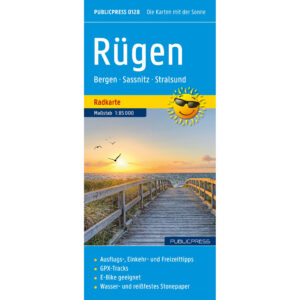
This detailed cycling map covers the whole of Rügen and is designed for both leisurely leisure rides and more demanding cycling stages. The map provides a complete overview of the island’s network of cycling and long-distance routes and is suitable for both planning and active use on trips.
The front of the map shows the entire cycling network on Rügen, with clearly marked cycling routes and connections between towns, coastal areas and natural areas. On the reverse side, selected excursion destinations and sights are presented, conveniently described for quick orientation along the way. The map covers central areas such as Bergen, Sassnitz and Stralsund, as well as the coastal and rural landscapes around the island.
The map is printed on a particularly durable material that makes it both water and tear resistant. It can therefore withstand use in all weathers and is well suited to outdoor activities. GPX tracks can be downloaded for use in GPS devices, and the map is well suited to both regular bikes and electric bikes.
The map is in German, but can easily be used by travelers with no knowledge of German. Road and cycling maps are mainly based on symbols, route markings and place names and provide quick and intuitive orientation regardless of language.
The product is released in 2025.