

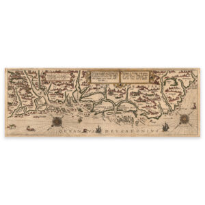
 Fosen Peninsula 1592


Fosen Peninsula 1592
Historical nautical map made with the technique of hand-colored lithography from 1592 over the area from the Fosen Peninsula, down the coast, around Stadt up to and including Florø. The map is delivered in original size 57 x 20.1 cm. The size with frame and passepartout is 73 x 37.1 cm. Would you like the map in a different size? Just get in touch – we’ll be happy to give you a quote for customization.