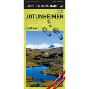
Description
Jotunheimen mountain map (CK 45) from Cappelen Damm Kart is a newly revised mountain map published in 2017, and is part of the Cappelen Damm mountain map series (no. 45). The map is printed on weather-resistant paper that can withstand both bad weather and rough use in the high mountains.
The map has two different scales. One side shows the central area Gjendesheim – Spiterstulen – Krossbu – Fondsbu at a scale of 1:50,000, which provides a very detailed overview for trip planning and navigation. The other side has a scale of 1:100,000 and covers a larger area, including Hurrungane, Mørkrisdalen, Lom and Sikkilsdalen.
The map shows both marked summer trails and groomed winter routes. The edition includes updated hiking routes, new ski trails and staked winter routes. Important changes have also been incorporated, including the fact that the DNT cabin Torfinnsbu is no longer serviced.
Jotunheimen is one of Norway’s most popular mountain areas, and this map provides a solid and up-to-date basis for both hiking and skiing.
Cappelen Damm no longer publishes maps and atlases. This product is sold from existing stock, and will be available while stocks last. When the stock is empty, the map will not be printed in a new edition.