Description
This chart package covers the coastal areas of Kent and Sussex in the south of England, including parts of the English Channel and key rivers and estuaries in the region. The chart package is well suited to both voyage planning and execution, providing a solid foundation for navigation in an area with heavy traffic and complex tidal conditions.
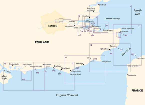
The maps cover the Thames Estuary and upstream, as well as the Medway and Swale areas, as well as the coastline from the Isle of Wight in the west to Dover and on to Calais. The area includes key ports, marinas and approaches, providing good coverage for both coastal and river navigation. Up-to-date depth data and official hydrographic information are combined with additional data to provide high precision and ease of use.
The map pack consists of 17 map sheets in A2 format, delivered in a sturdy plastic folder. The charts provide the necessary information for crossings, coastal navigation and detailed approaches to ports and marinas. Several areas are shown at a larger scale for better detail, including along the Thames, River Medway and Swale, as well as port areas such as Dover, Brighton and Ramsgate.
The map pack includes the following coverage: Thames Estuary South with overview maps for voyage planning. Detailed maps of the Thames from the sea up to Tower Bridge, including several high detail segments. River Medway from the inlet up to Allington Lock with associated harbor plans. The areas around The Swale and Whitstable with separate map sheets and harbor plans. The coastline from North Foreland via Dover and Dungeness to Beachy Head and on to the Isle of Wight. Also included are detailed harbor plans for Ramsgate, Dover, Calais, Brighton, Shoreham and Littlehampton.
The map package is designed for convenient navigation and also includes access to digital maps via a mobile application. The clear cartography and high level of detail make it suitable for both planning and active use along the way.
Release year: 2024.