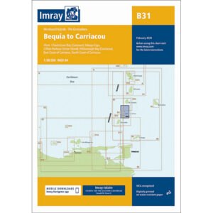
Description
This boating map covers the sailing area between Bequia and Carriacou in the Windward Islands / Grenadines in the Caribbean. The chart provides detailed plans for the islands and waters of a very popular area for island hopping and recreational sailing.
The map includes Clifton Harbour (Union Island), Tobago Cays, Hillsborough Bay (Carriacou), as well as the east and south coasts of Carriacou. Known for its short sailing distances, well-protected anchorages and stable wind conditions, the map is suitable for both local sailing and as part of longer routes through the Grenadines.
Imray is a recognized British chart manufacturer with extensive experience in nautical cartography for leisure and long-distance sailing. Their charts have been developed with a focus on high readability, practical navigation and clear presentation of navigation-relevant information, especially adapted to tropical sailing areas.