Description
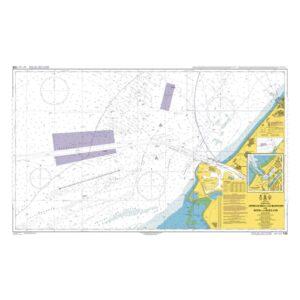
British Admiralty Chart 122 covers the approach to Europoort and the adjacent waters off Rotterdam, including main channels, traffic separation zones, anchorage areas and navigational installations. The chart provides a detailed overview of a complex and heavily trafficked sea area with extensive commercial shipping.
Europoort is part of the Port of Rotterdam – Europe’s largest port area – and the map is used both for planning and implementing approaches for larger vessels. It is also suitable as a reference chart for navigators traveling in the North Sea with calls to the Netherlands.
British Admiralty charts are official nautical charts with high cartographic precision and are used internationally by both professional and private navigators.