Description
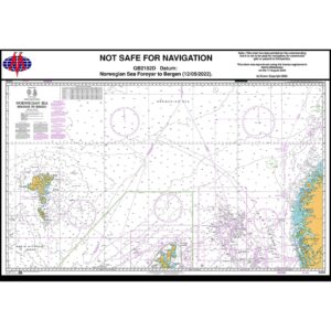
British Admiralty Chart 2182D is an official chart published by the UK Hydrographic Office and covers parts of the Norwegian Sea between the Faroe Islands (Føroyar) and Bergen. The chart is intended for oceanic and coastal navigation in a weather-prone and busy sea area used by both commercial shipping and experienced leisure sailors.
The map provides an overall navigational basis for sailing between the Faroe Islands and the Norwegian coast and shows depth conditions, submarine banks, recommended routes, traffic separation, navigational hazards and important references for planning and conducting voyages in the Norwegian Sea. Insert map sections provide a supplementary overview of selected coastal areas.
British Admiralty nautical charts are used internationally by professional shipping and meet the requirements of official navigation. Printed on durable paper and continuously updated through Admiralty Notices to Mariners, the charts provide a high degree of reliability and navigational safety in demanding waters.