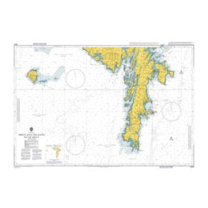
British Admiralty Chart 3283 – Shetland Islands, South Sheet

Official British Admiralty nautical chart covering the southern parts of the Shetland Islands, adapted for coastal navigation and transit.

Delivery is made in cooperation with StormGeo UK, official distributor of Admiralty maps. If the map is not in stock in Norway, it will be sent separately by DHL Express from the UK. Normal delivery time is 2-4 working days to most addresses in Norway. If delivery time is critical, please contact us and we will try to arrange the fastest possible delivery directly to the ship or port.

97,03 

British Admiralty

    Description

    This British Admiralty chart covers the southern Shetland Islands and adjacent waters in the North Atlantic. The chart provides a comprehensive overview of the coastline, islands, reefs, depths and navigation marks, providing a solid foundation for safe navigation in complex and weather-affected waters.

    The chart is suitable for coastal navigation, transit and voyage planning around the south of Shetland. Developed for professional navigators, it provides reliable support for both scheduled and other commercial traffic in the area.