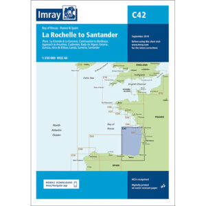
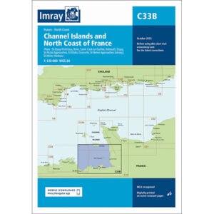
Description
This boating map covers the Channel Islands and the northern coast of France, focusing on the areas around Jersey, Guernsey and the adjacent French coast. The map includes detailed plans and approaches to St. Peter Port, St. Helier, Granville, Saint-Cast-le-Guildo, Dahouët, Erquy, Saint-Malo, Granville and associated anchorage and port areas.
The chart is well suited for leisure boats and sailboats traveling in the English Channel, either as part of coastal sailing or when crossing between the Channel Islands and France. The area is known for very strong tidal currents and large tidal differences, and the chart provides a solid basis for precise route planning and safe navigation.
Imray is a recognized British chart manufacturer with extensive experience in nautical cartography for leisure and long-distance sailing. Their charts are developed with a focus on high readability, practical use and clear presentation of navigation-relevant information.