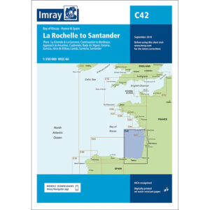
Description
This boating map covers the Bay of Biscay coastline from La Rochelle in France to Santander in Spain. The map includes detailed plans and approaches to key ports and harbors such as Gironde, La Garonne, the approaches to Bordeaux, Arcachon, Capbreton, Rade de Higuer, Getaria, Zumaia, Abra de Bilbao, Laredo, Santoña and Santander.
The chart is well-suited for leisure boats and sailboats crossing or sailing along the Bay of Biscay, either as part of a longer ocean crossing or a coastal voyage. It provides a solid foundation for route planning and navigation in an area known for changing weather conditions, currents and tidal influences.
Imray is a recognized British chart manufacturer with extensive experience in nautical cartography for leisure and long-distance sailing. The charts are designed with a focus on readability, practical use and clear presentation of navigation-relevant information.