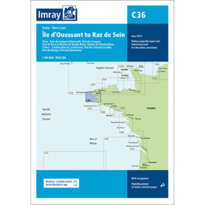
Description
This boating map covers the coastline of Brittany’s west coast from Île d’Ouessant in the north to Raz de Sein in the south. The map includes detailed plans and approaches to Baie de Lampaul (Ouessant), Port du Conquet, Port de Brest, Marina du Moulin Blanc, L’Elorn and Aulne rivers, Port de Camaret-sur-Mer, Port de Morgat and the Douarnenez area, among others.
The chart is well suited for leisure boats and sailboats navigating one of the most challenging waters along the French Atlantic coast. The area is renowned for its strong tidal currents, exposed stretches of sea and complex approaches, particularly around Ouessant and Raz de Sein. The map provides a solid foundation for route planning and safe navigation in these waters.
Imray is a recognized British chart manufacturer with extensive experience in nautical cartography for leisure and long-distance sailing. Their charts are developed with a focus on high readability, practical use and clear presentation of navigation-relevant information.