Description
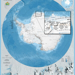
An overview map of Antarctica
Antarctica by the Norwegian Polar Institute depicts Antarctica and its surrounding seas at a scale of 1:10,000,000. It covers the region south of 55°S, providing an overview of the continent and the Southern Ocean.
The large format makes it suitable for display at home, in an office or in a classroom. Use it to explore polar geography and place destinations in a wider geographical context.
Unfolded poster edition
This is the unfolded wall map, measuring 82.5 × 95 cm. It is supplied rolled, without a frame. Map text and place names are in English. Published by the Norwegian Polar Institute; supplier reference 712901.
Explore more maps and books from the Norwegian Polar Institute.