Description
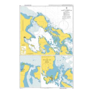
This British Admiralty chart covers Bahía Almirante and adjacent waters in the Bocas del Toro area on the Caribbean side of Panama. Depicting a complex coastal and island landscape with detailed depth indications, shoals, navigation marks and leads, the chart provides a precise basis for safe navigation in the area.
The map is well suited for coastal sailing, sailing between islands in the archipelago and approaching ports and anchorages in the bay. It has been developed for professional navigators, but is also relevant for recreational users who operate in the area and need a reliable map basis for planning and carrying out sailing.