Description
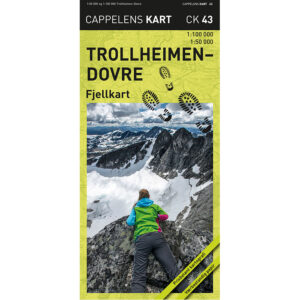
Trollheimen-Dovre – mountain map (part 43 in the series Cappelen Damm maps) is a detailed mountain map published in 2019. The map is folded and printed on weather-resistant paper, developed for use in demanding mountain terrain.
The map has two different scales: 1:100,000 on one side, which provides a good overview of the entire area, and 1:50,000 over central parts on the other side for more detailed planning and navigation.
The map shows summer trails and DNT’s twigged winter routes, and is therefore suitable for both hiking and skiing. Mountain shading provides a clear understanding of the terrain and makes it easier to visualize height differences and landscapes.
This map covers one of Norway’s most popular high mountain areas and is a practical tool for both short trips and longer mountain hikes.
Cappelen Damm no longer publishes maps and atlases. This product is sold from existing stock, and will be available while stocks last. When the stock is empty, the map will not be printed in a new edition.