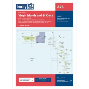
Description
This boating chart from Imray covers the US and British Virgin Islands, including St Croix, St Thomas, Tortola and surrounding islands in the northern Caribbean. Designed for coastal navigation and inter-island sailing, the chart combines overviews of major waters with detailed plans of key ports and anchorages.
The map shows coastlines, depths and key sailing areas. In addition, it contains detailed plans for Frederiksted and Christiansted on St Croix, Green Cay Marina, Road Harbour on Tortola and Charlotte Amalie on St Thomas, among others, making it practical both during the voyage itself and when planning routes and approaches. Because the area has many islands and varying coastlines, this is a useful master chart for yachts and sailboats operating in the Virgin Islands region.
Imray is a well-established British manufacturer of nautical charts with extensive experience, and their boating charts have been developed with a focus on practical use for sailors and cruisers in international waters. Printed on water-resistant paper, this chart is a robust choice for active use on board.