

 Jærens rev 1962


Jærens rev 1962
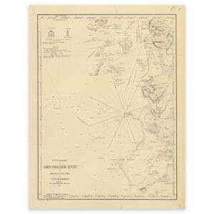
Historical nautical chart from 1862 of the stretch Jærens rev to Tananger. Feistein lighthouse was established as an approach lighthouse in 1859, and the lighthouse sectors are marked in this map, which is a lithograph made by T. The map is delivered in its original size of 31.5 x 41.2 cm. The size with frame and passe-partout is 47.5 x 58.2 cm. Do you want the map in a different size? Just get in touch – we’ll be happy to give you a quote for customization.