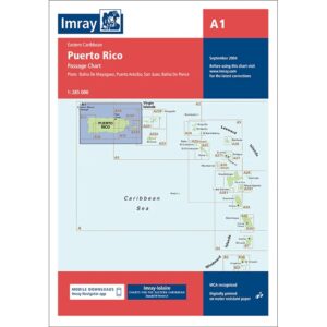
Description
This boating chart from Imray is an overview and passage chart covering Puerto Rico and surrounding waters in the eastern Caribbean. The chart provides a clear overview of the sailing area around the island and the connections to the Virgin Islands and Leeward Islands, and is well suited for planning longer legs and overall navigation.
The chart is particularly suitable for long-distance sailors and leisure boats traveling between Puerto Rico and the islands in the eastern Caribbean. It serves as a useful supplement to more detailed coastal and harbor charts, and provides good support for route selection and sailing over open seas.
Imray is a recognized British manufacturer of nautical charts with extensive experience in cartography for leisure and long-distance sailing. Their boating charts are developed with a focus on clarity, legibility and practical use on board.